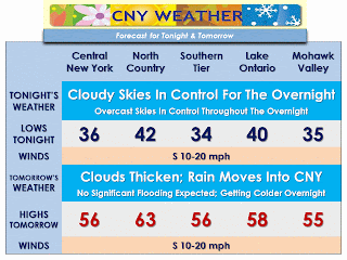
 Forecast Discussion: High pressure which has brought the central New York region beautiful, spring-like weather will bring more of the same as we start the work week with above-normal temperatures with tomorrow's highs approaching some regional records. Heading through the overnight into Tuesday, an area of showers will be working through our area associated with a low pressure system which has given parts of the Midwest 6"+ of snowfall over the last few days. This system will also usher in much cooler temperatures with 24-hour temperature departures of 10-20 degrees. Shortly after the skies dry out for Tuesday night, we will be keeping an eye on some possible light snowfall for the day on Wednesday. As of now it appears that any accumulations will generally be on the lighter end. Beyond that time, it appears that we may see another period of quiet weather; however, no return to spring-like conditions for a while.


No comments:
Post a Comment