N.W.S. Local Forecast


N.W.S. Local Forecast

Sunday, December 05, 2010

December 6th, 2010 Forecast

As winds continue to remain aligned and pump in moisture and from the lakes up north, we will see the lake effect snow continuing across the area. The question now comes to mind: Where will the heaviest of snow occur and when? As of right now, the main target area is the central and eastern Finger Lakes region south of I-90, and this includes the cities of Syracuse, Auburn, and Skaneateles. In these areas we could see as much as 10 inches maybe even a foot or more if the band stalls. If however the winds turn then accumulations could be greatly affected in these areas, probably less. As for school closings tomorrow, I believe there is a possibility that there could be some scattered ones, especially in the target areas, but there probably will be delays for certain. The same pattern will hold for the beginning of the week except lesser amounts will be likely.


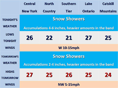
Tonight: Snow. Accumulations of 4-6 inches, heavier amounts in persistent snow bands (Possibly 10 inches or more.) Lows in the upper 20s. West wind 10-15mph


Monday/Monday Night: Snow showers continue. Accumulations 2-5 inches. Highs remain in the upper 20s. Lows in the lower 20s. Northwest wind 5-15mph.

Tuesday/Tuesday Night: Snow showers. Highs in the upper 20s. Lows in the upper 20s.


Wednesday: Snow showers likely. Highs in the upper 20s.

No comments: